
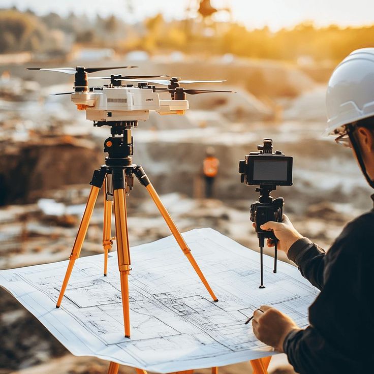
Drone Survey in Delhi the bustling capital of India, is expanding rapidly with continuous development in infrastructure, real estate, smart city initiatives, and environmental monitoring. In such a fast-growing city, traditional land surveying methods often struggle to keep up with the speed, scale, and accuracy required. This is where drone surveys in Delhi are emerging as a game-changer.
Delhi uses advanced UAV (Unmanned Aerial Vehicle) technology equipped with high-resolution cameras, LiDAR sensors, and GPS systems to capture aerial data. This data is then processed to create highly accurate topographical maps, 3D models, and orthomosaic images—helping businesses and government agencies make informed decisions quickly and cost-effectively.
Why Drone Surveying Is Rising in Delhi
Delhi’s unique infrastructure challenges and growing development requirements make drone surveys essential. Below are key reasons why drone mapping is becoming the first choice:
- ✔️ Faster data collection compared to manual surveys
- ✔️ High-precision mapping with centimeter-level accuracy
- ✔️ Ideal for large, complex, or inaccessible project sites
- ✔️ Cost-effective compared to traditional survey methods
- ✔️ Supports smart city & digital planning initiatives
- ✔️ Minimizes human risk in hazardous areas
From construction and metro expansion to urban forestry and agricultural analysis—drones are transforming the way surveys are conducted in the capital.
Applications of Drone Survey in Delhi
1. Construction & Infrastructure Development
Delhi has multiple ongoing and upcoming mega projects like highways, expressways, metro lines, and real estate developments. Drone surveys help in:
- Pre-construction site assessment
- Volume calculation for excavation
- Progress monitoring and reporting
- 3D modeling of construction sites
- Quality assurance and compliance
Developers and contractors use drone data to reduce project delays, manage resources, and optimize site planning.
2. Real Estate & Land Development
For builders, architects, and property developers in Delhi NCR, drone surveys assist in:
- Land measurement and mapping
- RERA compliance documentation
- Elevation models for planning building structures
- Virtual property inspection and presentation
With aerial surveying, real estate firms can showcase layouts and landscape designs professionally to buyers and investors.
3. Government & Smart City Projects
Delhi authorities increasingly adopt drone technology for:
- Urban planning and zoning
- Encroachment identification
- Road and public infrastructure planning
- Waste management planning
- River and water body monitoring
Drones enable faster decision-making and transparency in public development projects.
4. Environmental & Forest Survey
As pollution and environmental concerns grow, drones help monitor:
- Tree health and vegetation density
- River Yamuna pollution zones
- Illegal encroachments in forest areas
- Wildlife tracking and habitat mapping
- Thermal imaging for environmental studies
Delhi’s environmental bodies and NGOs rely on drones for sustainable planning.
5. Agriculture & Irrigation
Drone technology is also beneficial in Delhi’s semi-urban agricultural belts (outer Delhi regions):
- Crop health analysis (NDVI)
- Soil moisture and irrigation planning
- Pest and disease monitoring
- Precision agriculture mapping
Farmers gain insights to maximize crop yield efficiently.
Technology Used in Drone Surveying
Drone surveys in Delhi utilize modern tools including:
| Technology | Purpose |
|---|---|
| LiDAR Sensors | Laser scanning for high-precision elevation models |
| RTK/PPK GPS | Centimeter-level accuracy |
| Orthomosaic Imagery | High-resolution 2D mapping |
| 3D Photogrammetry | Realistic 3D models of terrain and buildings |
| Thermal Cameras | Heat mapping for infrastructure & environment |
These technologies ensure reliable and detailed data analysis for planning and execution.
Benefits of Drone Survey in Delhi
| Advantage | Description |
|---|---|
| Speed | Surveys completed 5-10x faster |
| Accuracy | Precision accuracy up to 2-3 cm |
| Safety | Reduces human risk on hazardous sites |
| Cost Efficiency | Saves manpower and project cost |
| Comprehensive Data | 2D, 3D, volumetric & thermal insights |
| Better Project Execution | Enhances monitoring and reporting |
Drone surveys also help project stakeholders communicate and collaborate more effectively with visual reports and digital data.
Industries Using Drone Survey Services in Delhi
- Construction & Real Estate Developers
- Government Planning Departments
- Railways & Metro Authorities
- Road & Highway Companies
- Forest & Environmental Agencies
- Agriculture Sector
- Oil & Gas & Utilities Companies
- Mining & Earthwork Contractors
- Architecture & Engineering Firms
Challenges & Regulations
Operating drones in Delhi requires compliance with DGCA rules, especially near sensitive zones and restricted airspace. Licensed drone operators ensure:
- Permission from authorities
- Safe flying practices
- Certified drone pilots
- Legal compliant flight planning
Hiring a professional DGCA-approved drone survey company ensures secure and accurate survey work.
Future of Drone Surveying in Delhi
With rapid smart city development, AI-powered analytics, GIS integration, and 5G technology, drone surveys are expected to become mandatory for:
- Digital infrastructure planning
- Smart traffic & road management
- Land digitization
- Disaster relief & emergency planning
- Automated construction site monitoring
The future of urban development in Delhi will rely heavily on aerial data intelligence.
Conclusion
A drone survey in Delhi offers unmatched accuracy, efficiency, and cost-effectiveness for projects across construction, real estate, agriculture, government planning, and environmental conservation. As the city continues to modernize, drone mapping technology will play a key role in shaping Delhi’s infrastructure and sustainability goals.
Whether you are a developer, contractor, urban planner, or environmental researcher—drone surveying provides reliable insights and transforms the way land and project data is collected and analyzed.
If you’d like, I can also provide:
✅ SEO keywords
✅ Meta title & description
✅ Google ranking blog version
✅ Brochure content for drone survey services
✅ Images & graphics prompts
Would you like a Delhi NCR drone survey service landing page as well?